La Job, 1650 Meter
|
|
| Talort: |
Barahona, 30 Meter |
| Höhenunterschied: |
1620
Meter |
| Streckenflug: |
Ja |
| Seilbahn: |
Nein |
| Windenschlepp: |
Nein |
| Walk and Fly: |
Nein |
|
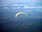
Von hier zu fliegen ist einfach traumhaft schön! Der Blick geht über das fruchtbare Tal hinüber zum Meer und dann noch zu der Bergkette Sierra de Bahoruco. Absolut Fabelhaft!
Location:: La Job is a mountain located E of Barahona, about 3 h 30 m from Santo Domingo. A four-wheel drive vehicle is required.
Launch Altitude AGL [m]:: 1650
Description:: The mountain is a part of the Sierra de Baoruco that runs WNW and grows nearly to 3000 m, parallel to the Sierra de Neyba in the north and also parallel to the Central Range. The takeoff faces E, which is the direction of the predominating winds all around the island at this altitude (Alisios). To the S, there are more mountains and valleys, to the N, Valle de Neyba. This valley is a big plain which descends up to 50 m under the sea level. Up in the mountains there are plenty of cold humid woods, down in the plains, desert.
Conditions and flight:: Flying from La Job is an amazing experience. The view of the valley, the Caribbean Sea and the Sierra de Bahoruco are outstanding. The takeoff is rather exposed to the trade winds which can sometimes be strong. That's why we takeoff by noon, once thermal activity in the lower mountaims and in the valley started kicking. The layer of meteo wind is pforced up and conditions get nice. The most obvious XC route is heading downwind (W), but that's until you see an endless sea of bushes and not-appropriate-for-landing cactus fields. So you either go N first (to the valley) or headwind (E) to the nearest town, Cabral. There is a fourth choice and is to go south to the bigger mountains, and end up in the south face of the Sierra de Bahoruco.
Maximum XC distance registered:: 35 km W
|
|
Besonderheiten und Webcam
Kontakt über Carribbean Free Flying:
JulianSV@CaribbeanFreeFlying.com |
Walk and Fly
| Ausgangspunkt: |
|
| Wegbeschreibung: |
|
| Sonstiges: |
|
Wissenswertes
| Anfahrt: |
La Job ist ein Berg E von Barahona rund 3 h 30 von Santo Domingo entfernt. Unbedingt erforderlich: 4-Radantrieb |
|

|
Startplätze |
| Startplatz: |
La Job |
| Startrichtung: |
N, S, WNW |
| Schwierigkeit: |
mittel
|
| Höhe über NN: |
1650 |
|
|
|
|
|
|
|
Landeplätze |
| Landeplatz: |
La Job |
| Schwierigkeit: |
mittel
|
| Höhe über NN: |
30 |
|
|
|
|
|
|
|
Umgebungskarte
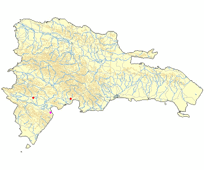
Interaktive Karte
|
Fluggebiete in der Nähe (Radius: 50 km) |
|
Nordamerika » Dominikanische Republic
La Hoz, 3000 Meter

| Entfernung: | 0 km
|
|
Höhenuntersch.:
|
1620
Meter
|
| Ort: | Barahona (Insel Hispanola Dom. Rep.)
|
| Streckenflug: | Nein
|
| Startplatz: |
Keine Angabe
|
| Landeplatz: |
Keine Angabe
|
Ca. 3,5h von Santo Domingo, nur mit Allrad erreichbar. Start auf 1650m GND. Der Startplatz mit seiner riesigen großen Wiese ist ein Genuss.
...
|
|
|
Nordamerika » Dominikanische Republic
Galvan, 1030 Meter
| Entfernung: | 45 km
|
|
Höhenuntersch.:
|
1030
Meter
|
| Ort: | Galván
|
| Streckenflug: | Ja
|
| Startplatz: |
mittel
|
| Landeplatz: |
mittel
|
Es geht hier richtung S mit herrlichem Blick über das Valle de Neyba. Hier ist es in der Luft sehr trocken wegen der Central Range, die die Luft...
|
|
|
Nordamerika » Dominikanische Republic
La Playita, 0 Meter
| Entfernung: | 48 km
|
|
Höhenuntersch.:
|
0
Meter
|
| Ort: | Azua
|
| Streckenflug: | Nein
|
| Startplatz: |
Keine Angabe
|
| Landeplatz: |
Keine Angabe
|
Location:: The takeoff is about 25 m S from Azua (1 h 45 m from Santo Domingo). A four-wheel drive vehicle is recommended.
Launch...
|
|
|
|
|
|
|  |
|