Galvan, 1030 Meter
|
|
| Talort: |
Galván, 0 Meter |
| Höhenunterschied: |
1030
Meter |
| Streckenflug: |
Ja |
| Seilbahn: |
Nein |
| Windenschlepp: |
Nein |
| Walk and Fly: |
Nein |
|
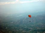
Es geht hier richtung S mit herrlichem Blick über das Valle de Neyba. Hier ist es in der Luft sehr trocken wegen der Central Range, die die Luft filtern. Das führt zu einer starken Thermik, die Euch auf über 1.400 Höhenmetern bringt und weit zum Meer und über das Tal blicken lässt.
Location:: Galvan is a town located by the Sierra de Neyba in the Valle de Neyba, 10 km E from a town also called Neyba. The takeoff is 3 h 30 m W from Santo Domingo. A four-wheel drive vehicle is required.
Launch Altitude AGL [m]:: 1030
Description:: The takeoff is facing S, looking at the great Valle de Neyba. This part of the island has very dry conditions, because the great Central Range filters moisture in the Alisios wind blowing NE. The Sierra de Neyba runs parallel to the Central Range, 30 kms S.
Conditions and flight:: With an amazing altitude in the takeoff, this is one of the 4 best XC flying sites. This range is protected from the Alisios winds by the Central Range and is also out of reach of the sea breeze entering the valley (because of the takeoff altitude and distance to the sea).
So you may find strong thermal conditions (+3 to +6) with healthy cumulus forming with bases over 1400 m AGL most of the time). Thermals are wide and well formed, with rather strong cores.
There are several XC possibilities, as you can fly along the range either W or E. You can also try getting into the valley where some dust devils can be seen once in a while.
When cloudbase is high, the range can be crossed and flown on the N face, with an obvious chance to fly into the Valle de San Juan.
Maximum XC distance registered:: 52 km
|
|
Besonderheiten und Webcam
Kontakt über Carribbean Free Flying:
JulianSV@CaribbeanFreeFlying.com |
Walk and Fly
| Ausgangspunkt: |
|
| Wegbeschreibung: |
|
| Sonstiges: |
|
Wissenswertes
| Anfahrt: |
Galván ist eine Stadt nahe der Sierra de Neyba im Tal Neyba rund 10 km E von der gleichnamigen Stadt. Nur mit 4-Radantrieb ist der Start zu erreichen. |
|

|
Startplätze |
| Startplatz: |
Galván |
| Startrichtung: |
S, NE |
| Schwierigkeit: |
mittel
|
| Höhe über NN: |
1030 |
|
|
|
|
|
|
|
Landeplätze |
| Landeplatz: |
Galván |
| Schwierigkeit: |
mittel
|
| Höhe über NN: |
0 |
|
|
|
|
|
|
|
Umgebungskarte

Interaktive Karte
|
Fluggebiete in der Nähe (Radius: 50 km) |
|
Nordamerika » Dominikanische Republic
La Hoz, 3000 Meter

| Entfernung: | 45 km
|
|
Höhenuntersch.:
|
1620
Meter
|
| Ort: | Barahona (Insel Hispanola Dom. Rep.)
|
| Streckenflug: | Nein
|
| Startplatz: |
Keine Angabe
|
| Landeplatz: |
Keine Angabe
|
Ca. 3,5h von Santo Domingo, nur mit Allrad erreichbar. Start auf 1650m GND. Der Startplatz mit seiner riesigen großen Wiese ist ein Genuss.
...
|
|
|
Nordamerika » Dominikanische Republic
La Job, 1650 Meter
| Entfernung: | 45 km
|
|
Höhenuntersch.:
|
1620
Meter
|
| Ort: | Barahona
|
| Streckenflug: | Ja
|
| Startplatz: |
mittel
|
| Landeplatz: |
mittel
|
Von hier zu fliegen ist einfach traumhaft schön! Der Blick geht über das fruchtbare Tal hinüber zum Meer und dann noch zu der Bergkette Sierra...
|
|
|
|
|
|
|  |
|