Kauahei, 408 Meter
          
Talort:
Napier
Höhe Talort:
0 Meter
Höhenunterschied:
408
Meter
Start Richtungen:
Seilbahn:
Nein
Streckenflug:
Ja
Soaring:
Keine Angabe
Windenschlepp:
Nein
Walk and Fly:
Nein
Ski and Fly:
Nein
Drachen:
Keine Angabe
UL:
Keine Angabe
Google Maps:
Qualität Fluggebiet:
Qualität dieser Seite:
Statistik:
Adoption (User):
-
Zuletzt bearbeitet:
18.12.2005
This site is located on the southern end of the Kaokaoroa Range, directly north of Otane. It is possible for the Hang Glider to land above again.
Bewertung der Fluggebiets- und der Seitenqualität
Besonderheiten und Webcam
For all information and rules please contact Airplay Paragliding before flying at enquiries@airplay.co.nz. Also for please contact the owners of the land before flying:
Road to starting location- Tim O'Brien. + 64 6 8781522
Takeoff - Trevor Trew. + 64 6 8568081 |
Wissenswertes
Anfahrt:
Hawkes is located directly at the coast along the National Couch Route, and is reached with a car in under a half days drive from all cities is New Zealand. If you have time check out the other flying sites in the region (8 to be exact) however only with 4 wheel drive. You will find the entrance to this flying site on the 'Te Aute Trust Road' from the SH2 between Otane and Lake Poukawa.
Sonstiges:
New Zealand's Hawkes Bay is renowned for its landscape, wine and Mediterranen lifestyle.
Startplätze
Startplatz:
Kauahei
Startrichtung:

S W Schwierigkeit:
schwer
Höhe über NN:
408
|
Landeplätze
Landeplatz:
Kauahei
Schwierigkeit:
schwer
Höhe über NN:
0
|
Download: Google Earth Dateien für Fluggebiet und Flugdaten (IGC, OLC)
Download: Google Earth Dateien (KML-Format), Flugdaten (IGC Format)
Die letzten 3 Flüge
Leider keine OLC Daten vorhanden.
Flugdaten von www.paraglidingforum.com
Leider keine OLC Daten von www.paraglidingforum.com vorhanden.
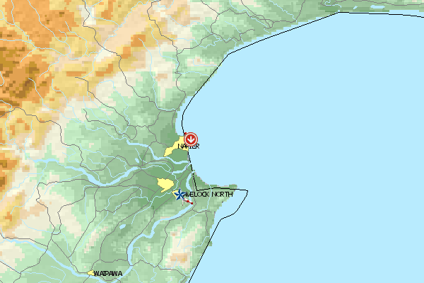
Umgebungskarte
  Fluggebiet  Flugschule  Aktuelle Position | Orte in der Nähe
Napier City (0 km)
Napier (0 km)
Onekawa (0 km)
Ahuriri (1 km)
Port Ahuriri (1 km)
Westshore (3 km)
Greenmeadows (7 km)
Mast (7 km)
Awatoto (8 km)
Meeanee (8 km)
Puk-kura (8 km)
Bay View (8 km)
Taradale Town District (8 km)
Taradale (8 km)
Petane (9 km)
|
Fluggebiete in der Nähe (Radius: 50 km)
Australien / Ozeanien » Neuseeland
Entfernung:
0 km
Höhenuntersch.:
24
Meter
Ort:
Napier
Streckenflug:
Ja
Startplatz:
leicht
Landeplatz:
leicht
Start Richtungen:
Beautiful beach flying site on Hawkes Bay with many possibilities for both the beginner and experienced pilot. Hang Gliders fly here however, considerably further than the Paraglider. The record lies until after Wairoa.
Australien / Ozeanien » Neuseeland
Entfernung:
0 km
Höhenuntersch.:
61
Meter
Ort:
Napier
Streckenflug:
Ja
Startplatz:
mittel
Landeplatz:
mittel
Start Richtungen:
A crazy beach flying site with a high cliff. Caution with the power poles and the model airplanes, that are always racing around here. Please give yourself sufficent space and distance. Please do not land in the vicinity of the horses. You may not fly over Cape Kidnappers because of the...
Australien / Ozeanien » Neuseeland
Entfernung:
0 km
Höhenuntersch.:
244
Meter
Ort:
Napier
Streckenflug:
Ja
Startplatz:
schwer
Landeplatz:
schwer
Start Richtungen:
High and wide inland flight site. Toward south, the cliff edge is 8 km long, toward north nevertheless it is 2 km.
Flugschulen in der Nähe (Radius: 50 km)
Australien / Ozeanien » Neuseeland
Airplay Paragliding School
Hawkes Bay
Havelock North www.airplay.co.nz
Entfernung: 21 km
4 Stunden von Wellington auf der nördlichen Insel von Neuseeland findet ihr in dem kleinen Ort Havelock North die Paragliding Schule "Airplay"....
Alle Fluggebiete und Flugschulen in der Nähe anzeigen
|