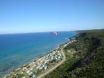
Canasi - Palmarejo, 85 Meter
          
Talort:
Canasi
Höhe Talort:
0 Meter
Höhenunterschied:
85
Meter
Start Richtungen:
Seilbahn:
Nein
Streckenflug:
Ja
Soaring:
Ja
Windenschlepp:
Nein
Walk and Fly:
Ja
Ski and Fly:
Nein
Drachen:
Ja
UL:
Nein
Google Maps:
Qualität Fluggebiet:
Qualität dieser Seite:
Statistik:
Adoption (User):
davidcalas seit 31.05.2008
Zuletzt bearbeitet:
22.12.2011
Pictures & Info
This is a coastal flying spot. Is a magical place with more than 10 km of slope in front of the Caribbean Sea.
Getting up us free, no turbulence close to the sea and a tempting thermal factory if you fly down wind.
Is half way from Varadero to Havana and close to the Breezes Jibacoa resort.
Bewertung der Fluggebiets- und der Seitenqualität
Flug
The flight here is very smooth
Walk and Fly
Ausgangspunkt:
Wegbeschreibung:
Sonstiges:
Wissenswertes
Sonstiges:
Havana City Paragliding Club
Kontakt:
Laminares
David Calás Lozano < david.calas -a- gmail.com>
Tel: +53-533 442 67
Eli Ecer < eliecergr -a- gmail.com>
Tel: +53-528 920 17
Luis García < lugarcia -a- airfrance.fr>
Mobil: +53-526 407 15
Startplätze
Startplatz:
Palmarejo
Startrichtung:

N NO Schwierigkeit:
leicht
Höhe über NN:
0
Easy ramp
|
Landeplätze
|
Download: Google Earth Dateien für Fluggebiet und Flugdaten (IGC, OLC)
Download: Google Earth Dateien (KML-Format), Flugdaten (IGC Format)
Die letzten 3 Flüge
Leider keine OLC Daten vorhanden.
Flugdaten von www.paraglidingforum.com
Leider keine OLC Daten von www.paraglidingforum.com vorhanden.
Umgebungskarte
  Fluggebiet  Flugschule  Aktuelle Position |
Fluggebiete in der Nähe (Radius: 50 km)
Nordamerika » Kuba » La Habana
Entfernung:
6 km
Höhenuntersch.:
85
Meter
Ort:
Playa Amarilla Jibacao
Streckenflug:
Ja
Startplatz:
leicht
Landeplatz:
Keine Angabe
Start Richtungen:

|
22.01.2010
|
 |
|
1 Votes
|
1482 Hits
|
| [robi] | | Blick nach Osten |
|
Video from Canasi
Pictures
Is a ridge soaring site with more than 10 km of slope. Have a look at the video from Canasi or the pictures from this beautiful place.
Sehr schönes Fluggebiet....
N 23° 08.784' / W 081° 48.010' 86m
Local Pilot...
Nordamerika » Kuba » La Habana
Entfernung:
13 km
Höhenuntersch.:
68
Meter
Ort:
Playa Jibacoa
Streckenflug:
Nein
Startplatz:
Keine Angabe
Landeplatz:
Keine Angabe
Start Richtungen:
Pictures & Info
Dieses Gelände wird am häufigsten von den Piloten aus Havanna genutzt.
Start und Landung sind wirklich einfach, sprich anfängertauglich. Sehr gut um jede Menge Spaß zu haben.
Nordamerika » Kuba » Matanzas
Entfernung:
15 km
Höhenuntersch.:
300
Meter
Ort:
Pan de Matanzas
Streckenflug:
Ja
Startplatz:
mittel
Landeplatz:
Keine Angabe
Start Richtungen:
Pictures & Info
Pan de Matanzas mountain is located at about 10 km SW from the city of Matanzas. It is the highest point in the valley “Valle de Yumurí” and rises up to 375 metres asl. 1500 meters north from it’s base is Corral Nuevo town, the home of about 50 families. In...
Flugschulen in der Nähe (Radius: 50 km)
Nordamerika » Kuba
Fallschirmspringen und Gleitschirmfliegen mit den Skydivers im Touristenghetto
Alle Fluggebiete und Flugschulen in der Nähe anzeigen
|


