Rostock-Eck, 2749 Meter


Talort:
Streden
Höhe Talort:
1403 Meter
Höhenunterschied:
1346
Meter
Start Richtungen:
Seilbahn:
Ja
Streckenflug:
Ja
Soaring:
Nein
Windenschlepp:
Nein
Walk and Fly:
Nein
Ski and Fly:
Ja
Drachen:
Nein
UL:
Nein
Qualität Fluggebiet:
Qualität dieser Seite:
Statistik:
Adoption (User):
Axel7 seit 19.09.2008
Zuletzt bearbeitet:
23.09.2008
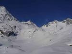
Great Flying area for walk&fly. Alternatives from Essener-Rostocker Hütte are Grosser Geiger 3360, Grosser Happ,Malhamspitze, Reggentörl, Simonyspitze.
Due to incoming weather and stronger winds the lower Rostock Eck was chosen this time (22.4.2008)

|
23.09.2008
|
 |
|
0 Votes
|
922 Hits
|
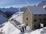
| [Axel7] | | Grosser Geiger the original walk&fly destination - too much wind this time |
|
[Bild hinzufügen]
|
 |
|
|
23.09.2008
|
 |
|
0 Votes
|
916 Hits
|
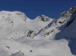
| [Axel7] | | the ski-tour track with the Rostock Eck on the left and the Reggentörl in the middle |
|
[Bild hinzufügen]
|
|
|
|
23.09.2008
|
 |
|
0 Votes
|
862 Hits
|
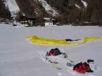
| [Axel7] | | landing in Streden with airport dimensions with the car just nearby - so no more walking required |
|
[Bild hinzufügen]
|
|
Bewertung der Fluggebiets- und der Seitenqualität
Flug
Take of to the nw/w 200 Meters below the summit flying down the valley directly to streden. Landing in Streden on the parking place.
Schwierigkeit
on the way up to the hut beware of avalanche areas.
Other than that high alpine sourrounding
Besonderheiten und Webcam
| Great area for walk&fly, very friendly alpine hut, extraordinary food and kitchen/first class and friendly staff. Not crowded at all and that way providing great alpine ambiance. |
Walk and Fly
Ausgangspunkt:
2-3hrs from streden to the hut - if you do not like walking the material lift takes backpack and people.
From the hut to the summit in 2,5hrs due to very much snow.
Take off to the nw and great near terrain flight back to streden (low as low can be with skis and snow available).
Very much recommended because lots of touring possibilities nearby allowing virtually al take of directions.
Wegbeschreibung:
Sonstiges:
Wissenswertes
Unterkunft:
top class
Anfahrt:
from the north unfortunately an additional 2hrs by car needed as compared to other northern alps tours
Download: Google Earth Dateien für Fluggebiet und Flugdaten (IGC, OLC)
Download: Google Earth Dateien (KML-Format), Flugdaten (IGC Format)
Die letzten 3 Flüge
Leider keine OLC Daten vorhanden.
Flugdaten von www.paraglidingforum.com
Leider keine OLC Daten von www.paraglidingforum.com vorhanden.
Alle Fluggebiete und Flugschulen in der Nähe anzeigen