Conto Springs, 75 Meter


Talort:
Margaret River
Höhe Talort:
2 Meter
Höhenunterschied:
73
Meter
Start Richtungen:
Seilbahn:
Nein
Streckenflug:
Ja
Soaring:
Keine Angabe
Windenschlepp:
Nein
Walk and Fly:
Nein
Ski and Fly:
Nein
Drachen:
Keine Angabe
UL:
Keine Angabe
Google Maps:
Qualität Fluggebiet:
Qualität dieser Seite:
Statistik:
Adoption (User):
-
Zuletzt bearbeitet:
13.12.2005
One of the best known coastal flight zones in Western Australia, very well liked by the beginner. The impressive sand plain and the good flying possibilities make the surfing sand beach popular and almost perfect.
Bewertung der Fluggebiets- und der Seitenqualität
Flug
You are taken in corresponding wind directly with towards the top! The wind changes constantly, Tipp: Take notice of the waves out of the corner of your eye to see what is developing. Landing is in the picnic-area near the parking lot. Top landing is also possible, but more difficult because the start place is very little and there are many shrubs there.
Wissenswertes
Anfahrt:
From Margaret River south along the Caves Road in the direction of Lake Cave. Then turn right before the Kiosk, then left along the dirty and unsealed road in the direction of Conto Springs. Shortly before you reach the beach you will see two foothpaths on the right that will show you the way to the starting place.
Sonstiges:
You will find Margaret river in the middle of Bunbury and Cape Naturaliste, approx 200km south of Perth. This lovely landscape offers all wind directions available at the coast side, by NE over W until S. The best time to fly is in the spring or autumn so to exploit the advantages of the western back wind or front wind. Also in the summer, flights over the lake are yet always very good.
Startplätze
Startplatz:
Conto Springs
Startrichtung:

SW W Schwierigkeit:
mittel
Höhe über NN:
75
|
Landeplätze
Landeplatz:
Conto Springs
Schwierigkeit:
sehr leicht
Höhe über NN:
0
|
Download: Google Earth Dateien für Fluggebiet und Flugdaten (IGC, OLC)
Download: Google Earth Dateien (KML-Format), Flugdaten (IGC Format)
Die letzten 3 Flüge
Leider keine OLC Daten vorhanden.
Flugdaten von www.paraglidingforum.com
Leider keine OLC Daten von www.paraglidingforum.com vorhanden.
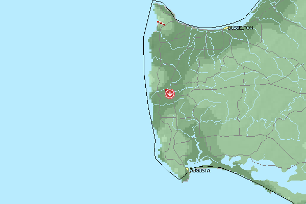
Umgebungskarte
  Fluggebiet  Flugschule  Aktuelle Position | Orte in der Nähe
Margaret River (0 km)
Bramley (6 km)
East Witchcliffe (9 km)
Cowaramup (9 km)
Witchcliffe (10 km)
Rosa Brook (11 km)
Forest Grove (13 km)
Yates, Mount (19 km)
Metricup (19 km)
Yelverton (22 km)
Arumvale (24 km)
Yallingup (28 km)
Karridale (30 km)
Carbunup (30 km)
Hamelin Island (30 km)
|
Fluggebiete in der Nähe (Radius: 50 km)
Australien / Ozeanien » Australien » Western Australia
Entfernung:
0 km
Höhenuntersch.:
198
Meter
Ort:
Margaret River
Streckenflug:
Ja
Startplatz:
schwer
Landeplatz:
leicht
Start Richtungen:
A high west facing mountain with good thermic conditions.
Australien / Ozeanien » Australien » Western Australia
Entfernung:
0 km
Höhenuntersch.:
8
Meter
Ort:
Margaret River
Streckenflug:
Ja
Startplatz:
sehr leicht
Landeplatz:
sehr leicht
Start Richtungen:
A long and flat section of coast with a soft sandy beach. In a western wind its possible to land on the naked bathers beach.
Australien / Ozeanien » Australien » Western Australia
Entfernung:
0 km
Höhenuntersch.:
8
Meter
Ort:
Margaret River
Streckenflug:
Ja
Startplatz:
sehr leicht
Landeplatz:
sehr leicht
Start Richtungen:
Very nice and beautiful coast with a lond beach- and naked beach. Mostly west winds!
Alle Fluggebiete und Flugschulen in der Nähe anzeigen